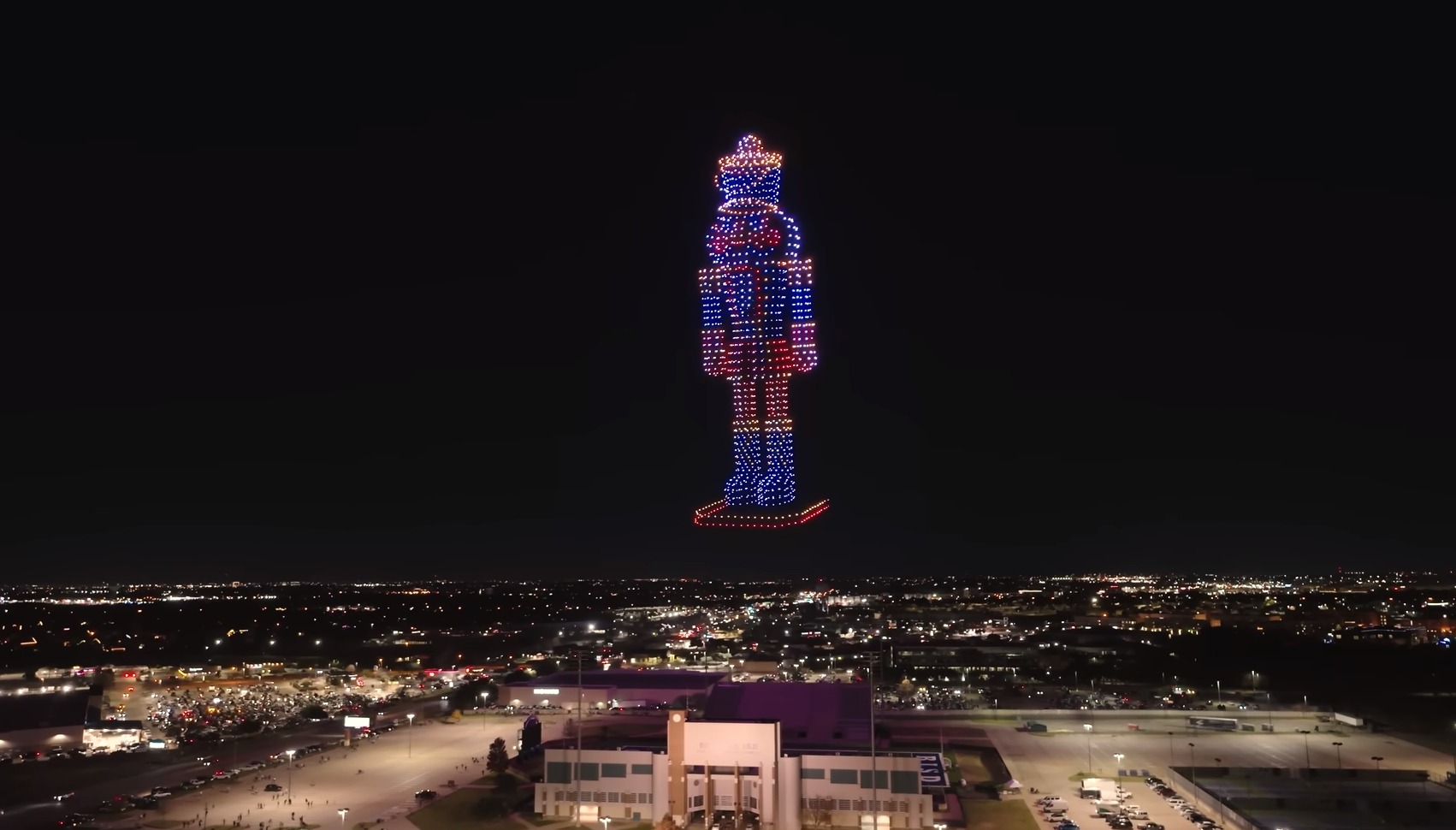
On December 21st, 2023, the night sky above North Richland Hills, Texas, USA, became a canvas for a breathtaking display of synchronized drone choreography. Sky Elements Drone Shows, the masterminds behind this Guinness World Record-breaking feat, orchestrated a ballet of over 1500 drones, leaving audiences mesmerized and wondering: what software powers such a mesmerizing spectacle?
While the specific program used by Sky Elements remains under wraps, a closer look at the process behind drone shows, like the one revealed in SPH Engineering’s “Behind the scenes – How to make a drone show” offers valuable insights.
Key Takeaways
- Creating a drone show involves preparing a drone choreography animation using 3D animation software.
- Drone show software can be used to run a virtual test to ensure all formations, lights, and directions are as planned.
- Managing show logistics and setting up the equipment are important steps in creating a successful drone show.
Getting Started with Drone Choreography
Understanding the Animation Process
Creating a drone show choreography involves preparing a drone choreography animation using any 3D animation software. Drones can create virtually any figure in three dimensions, including carrying fireworks or smoke generators on board. The animation process is similar to traditional 3D animation, where the idea is to deliver a story and emotion to the audience with a limited number of pixels. One major difference is that drone animation is meant to be seen from any direction, which requires additional considerations, such as speed and distance between each drone.
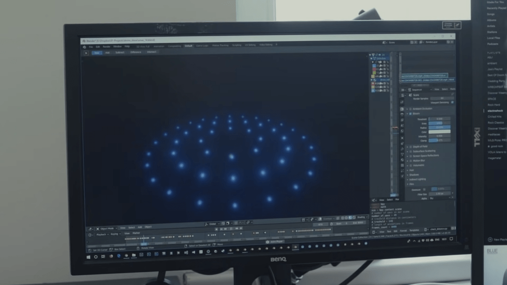
Applying Traditional 3D Animation Skills
Drone animation is a new field, and there are no best practices or tutorials available on the internet. Every trick or approach you come up with is an innovation, and that’s what makes it exciting. The rules that apply to traditional animation in general also apply to drone photography. However, drone animation presents new challenges, such as speed and distance, which are tested once the animation is created to ensure there’s no collision risk.
Considering Drone Animation Challenges
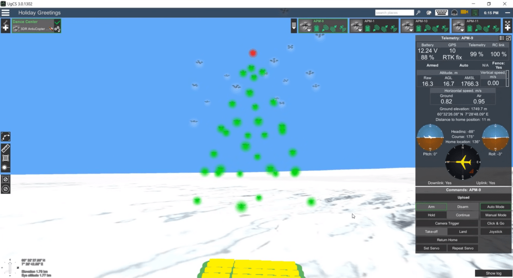
Drone animation presents new challenges, such as speed and distance, which are tested once the animation is created. Drones can reach the required speed if necessary, and changes can be made to the animation if needed. Once the animation is created, you can use drone show software to run a virtual test without damaging drones. This helps check if the projected takeoff and landing positions of drones are okay, all formations are as planned, lights work as expected, and the show faces the proper direction.
Innovating in a New Field
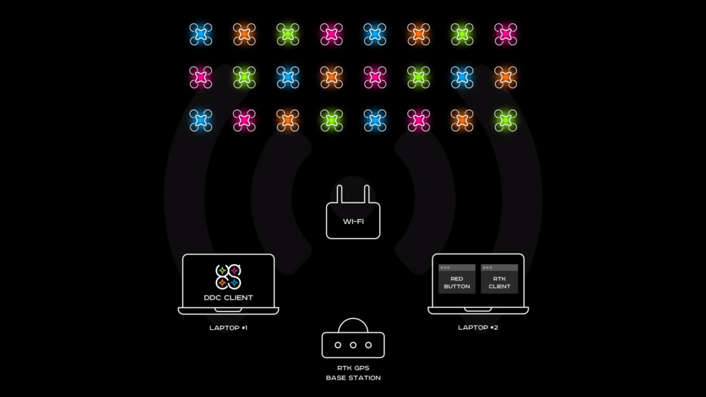
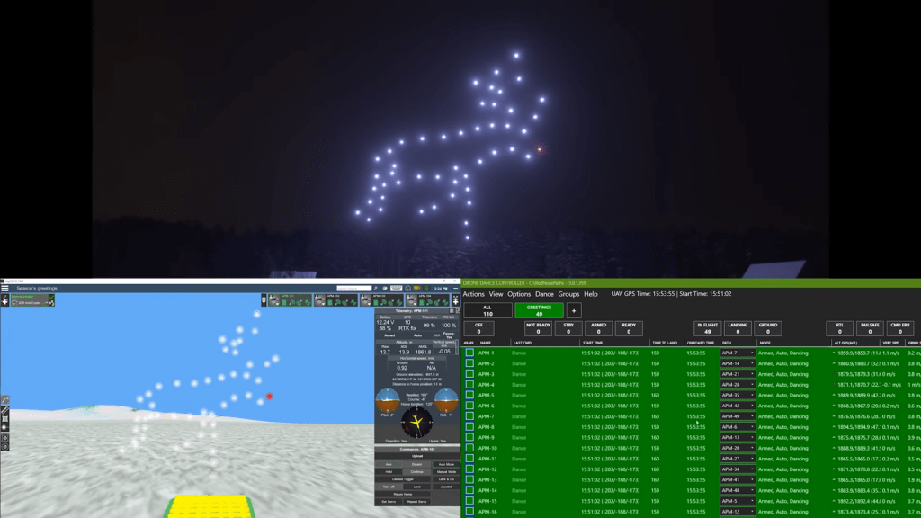
Controlling dozens or even hundreds of drones is not an easy task, but drone show software helps with the hardest part. The show operator has two setups of drones under control, and the next step is logistics, defining where and when the show will be set. The field must be large enough to accommodate all the drones ready for takeoff, and the surface must be flat enough without tall grass or deep snow. Once everything is ready, put the drones in their respective positions, and drone show software automatically assigns the flight paths from the animation to each drone. The final step is to set the show time and let the drones know when to take off.
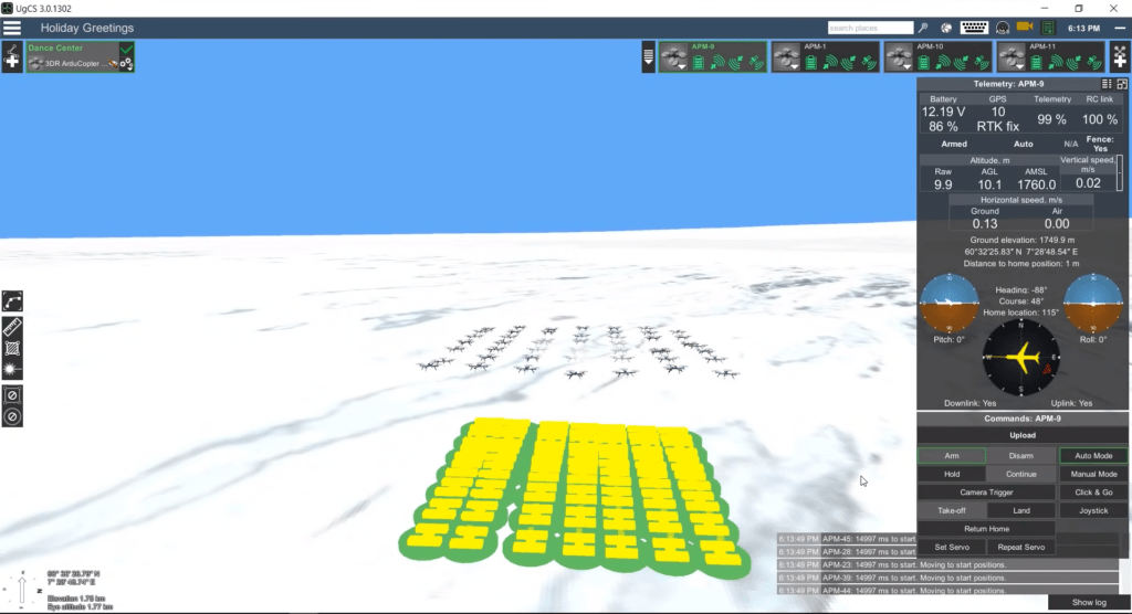
Drone show software displays all drone parameters in real-time, and all drone flight on a 3D map. It takes care of the most important part, safety, and has four safety layers to protect spectators. If something unexpected happens, such as a strong wind gust, the geofence automatically prevents drones from going beyond a certain perimeter. The control interface enables the operator to land each drone at any time, and a completely independent red button app uses a separate computer and radio channel to stop the show and land all drones. Finally, there’s a backup human pilot with a remote controller who could even take control over an individual drone and land it and that person could be you 🤫
Using Drone Show Software for Virtual Tests
Testing Speed and Distance
When it comes to creating a drone show, testing speed and distance is crucial to ensure safety and accuracy. After the animation for the drone choreography is prepared using 3D animation software, the next step is to check if the projected takeoff and landing positions of drones are okay and if all formations are as planned. This is where the drone show software comes in handy.
The drone show software allows the user to run a virtual test without damaging any drones. The software uses a so-called “software in the loop” virtual environment to simulate real-life drone behavior. This helps to check if there is any collision risk and if the drones can reach the required speed. If necessary, changes can be made right away.
In addition, the software can ensure the safety of spectators by limiting drone flying zones using a cylinder or polygon fence 🤔. This is especially important when controlling dozens or even hundreds of drones, which is not an easy task at all.
Once the animation is created and the virtual test is done, the next step is logistics. This includes defining where and when the show will be set and preparing the field for takeoff.
Managing Show Logistics & Safety
Ensuring Spectator Safety
When organizing a drone show, ensuring the safety of the spectators is of utmost importance. To achieve this, the show organizers need to limit the drone flying zones using a cylinder or polygon fence. The drone show software can help in this regard by assigning flight paths to each drone and ensuring that they do not go beyond a certain perimeter, thanks to the geofence feature.
In addition to the geofence, there are four safety layers to protect spectators in case of unexpected events:
You can learn more about fail-safes and safety measures in our previous article on “Failsafe for FPV Drones: What is it and How to Configure It.”
- The first layer: is the geofence itself, which automatically prevents drones from going beyond the perimeter.
- The second layer: is the control interface, which enables the operator to land each drone at any time.
- The third layer: is a completely independent red-button app that uses a separate computer and radio channel to stop the show and land all drones.
- Finally, the fourth layer: is a backup human pilot with a remote controller who could even take control over an individual drone and land it if necessary.
Setting Up the Equipment
Positioning the Drones
To start the drone show, the first step is to position the drones on a flat surface with a safety fence around the field. The distance between drones on the ground should be between two and a half to three meters. If planning to use 49 drones, a 324 square meter field is necessary to position them. If no such area is available, a platform for takeoff can be used, but extra caution is required during landing.
Scheduling the Show
After the pre-flight check, the final step is to set the show time and let the drones know when to take off. The drone show software allows pre-programming an exact starting time for all drones, so there is no need to worry about being late with the show.
Flight Path Upload: Now comes the moment of truth. The drone show software assigns specific flight paths to each drone, translating the animation into actionable instructions. These paths are then uploaded to the drones, equipping them with the knowledge of their aerial choreography.
Pre-Flight Check: Just like any well-oiled machine, a thorough pre-flight check is essential. The software meticulously analyzes all parameters, ensuring everything is within acceptable limits before the grand finale. Safety is paramount, and the software acts as a vigilant guardian, ready to intervene if anything goes awry.
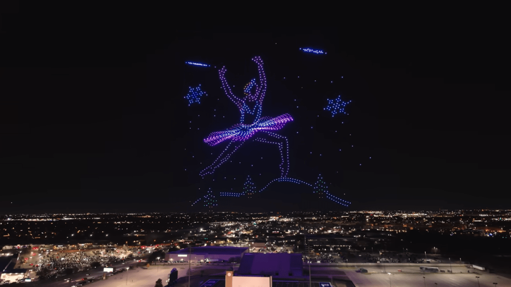
Takeoff and Beyond: With a final press of a button, the drones gracefully ascend into the night sky. The software takes over, guiding their movements with precision and ensuring they paint the canvas of the night with their synchronized light. It’s a conductor leading an orchestra of drones, each movement a testament to the power of technology and creativity.
Safe Landing: After a mesmerizing performance, the software guides the drones back to their designated landing zones. The show ends with a gentle touchdown, marking the culmination of meticulous planning and technological prowess.
Beyond the Software
While the software plays a crucial role in orchestrating the spectacle, it’s important to remember that it’s just one piece of the puzzle. The success of a large-scale drone show also relies on the expertise of skilled drone pilots, meticulous planning, and favorable weather conditions.
The Future of Drone Shows
As drone technology continues to evolve, we can expect even more intricate and awe-inspiring drone shows in the future. The software that powers these events will continue to push the boundaries of what’s possible, allowing us to experience the magic of synchronized drone flight like never before.
In Conclusion
The 1500+ drone event above North Richland Hills wasn’t just a record-breaking feat; it was a testament to the power of technology and creativity. The software that orchestrated this mesmerizing spectacle is a glimpse into the future, where drones will not only light up the night sky but also redefine the possibilities of entertainment and artistic expression.
I hope this revised article, incorporating insights from the “Behind the scenes” video, provides a more comprehensive and engaging look at the software behind these incredible drone shows.
One Reply to “1,500 Drones Light Up the Sky for Christmas Celebration: Behind the Scenes of the World’s Largest Drone Show”