Are you a drone enthusiast looking to take your aerial photography and videography skills to new heights? Well, you’re in luck! We’ll explore a selection of must-have apps that every drone pilot should consider adding to their toolkit. These apps are designed to enhance your flying experience, ensure safety and compliance, and unlock a world of creative possibilities. From flight planning and weather monitoring to video editing and location scouting, we’ve got you covered. So, get ready to soar as we embark on an exciting journey into the world of drone apps!
Benefits of Using Drone Apps
Using drone apps offers numerous benefits for drone pilots, regardless of their experience level or purpose of flying. Here are some key advantages of incorporating drone apps into your flying routine:
- Time-saving Flight Planning: Drone apps streamline flight planning with waypoint marking and automated actions.
- Real-time Weather Updates: Access accurate weather information to plan flights and avoid unfavorable conditions.
- Flight Safety and Airspace Awareness: Stay within legal boundaries and comply with regulations using app-provided airspace data.
- Enhanced Camera Controls: Adjust camera settings and utilize automated modes for precise aerial photography or videography.
- Flight Telemetry and Data Logging: Analyze detailed flight data to evaluate performance and optimize future flights.
- Community and Social Sharing: Connect with fellow drone pilots, share experiences, and showcase your work on social media.
By harnessing the power of drone apps, you can streamline your workflow, stay informed, and maximize the potential of your drone. These apps offer an array of features and tools that save time, improve safety, and enhance your overall flying experience, enabling you to capture breathtaking aerial imagery with ease.
Whether you need precise airspace information, accurate weather forecasts, advanced mapping capabilities, video editing tools, or project management solutions, there is a diverse range of apps available to cater to your specific needs. Explore the vast possibilities with these essential apps and elevate your flying endeavors to new heights.
DJI GeoZone Map App (for DJI drones)
DJI GeoZone Map provides convenient access to essential information regarding flight restrictions:
- Access within DJI mobile apps: The DJI GeoZone Map is accessible within the DJI Fly app when using the DJI RCM1 controller or the DJI RC controller connected to Wi-Fi. In the DJI Fly app, simply tap the location on the top left of the screen to open the DJI GeoZone Map. Similarly, in the DJI RC app, tap the location on the top left of the screen to access the map.
- Exploring specific areas: Within the DJI GeoZone Map, you can search for specific areas using the search bar located at the top left of the screen. This allows you to examine the locations where you intend to fly your drone.
- Viewing flight restrictions: When viewing the DJI GeoZone Map, flight restrictions will be indicated on the map. If a restriction is displayed, you can tap on it to obtain further details on the left side of the screen. This provides you with additional information about specific restrictions or regulations in that area.
The DJI GeoZone Map, accessible through the DJI Fly app or the DJI RC app, offers a user-friendly interface for easily identifying and understanding flight restrictions. By utilizing this feature, you can ensure compliance with local regulations and fly your DJI drone safely and responsibly.
iFlight App (for iFlight drones)
While iFlight does not have a dedicated app, iFlight drones can often be configured and controlled using popular third-party apps such as Betaflight Configurator. These apps offer a range of benefits, including:
- Configuration and Tuning: Third-party apps like Betaflight Configurator allow pilots to fine-tune flight controller settings such as PID values, rates, and filters. This customization helps optimize the flight performance and responsiveness of iFlight drones.
ImpulseRC App (for ImpulseRC drones)
Similar to iFlight, ImpulseRC drones do not have a dedicated app. However, pilots can utilize compatible third-party apps like Betaflight Configurator or BLHeliSuite to configure and customize their ImpulseRC drones, providing benefits such as:
- ESC Configuration: With apps like BLHeliSuite, pilots can adjust electronic speed controller (ESC) settings for ImpulseRC drones. This includes parameters like motor timing, motor direction, and throttle response, enhancing the drone’s performance and efficiency.
BetaFlight Configurator (for BetaFPV drones)
BetaFlight Configurator provides drone pilots with a user-friendly interface to control and configure their BetaFPV drones, offering convenient access to essential features and functionalities:
- Access and Interface: The BetaFlight Configurator app provides an intuitive interface for pilots to control and configure their BetaFPV drones from a computer.
- Flight Parameters Adjustment: Pilots can fine-tune flight parameters such as PID values, rates, and flight modes to achieve desired flight characteristics.
- Customization Options: The app offers extensive customization options, allowing pilots to personalize their BetaFPV drone’s performance and behavior.
- Firmware Updates: BetaFlight Configurator enables easy firmware updates, ensuring access to bug fixes, performance enhancements, and new features.
With BetaFlight Configurator, BetaFPV drone pilots have a powerful tool for optimizing and customizing their drone’s flight performance and overall experience.
Eachine FPV (for Eachine FPV racing drones)
The Eachine FPV app is tailored for Eachine FPV racing drones, offering the following benefits and purposes:
- Live Video Streaming: Pilots can enjoy real-time video streaming directly on their mobile devices using the Eachine FPV app. This immersive FPV experience enhances situational awareness and precise maneuvering during racing or freestyle flights.
Flight Planning & Weather Apps
AirMap App
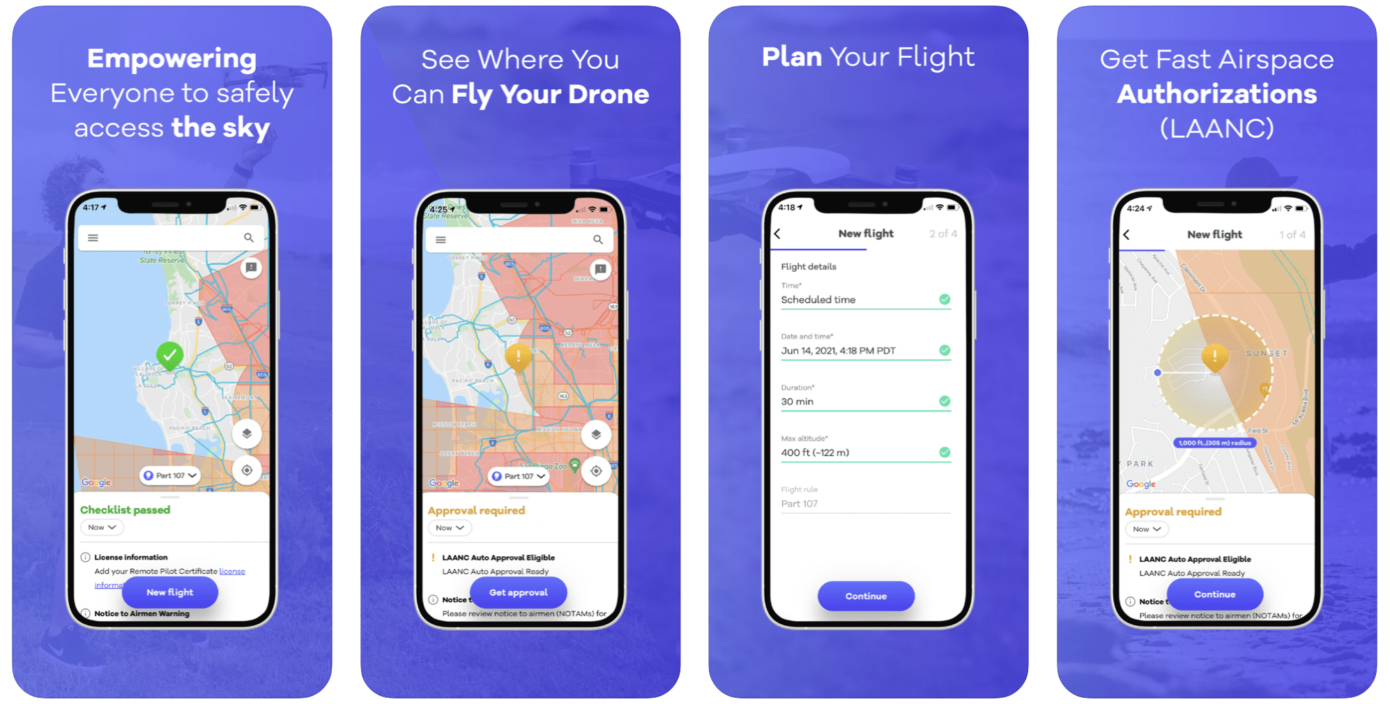
AirMap App offers valuable features that enhance the safety and legality of your drone flights:
- Easy-to-understand flight information: The app simplifies access to critical details about your intended flight locations. By checking airspace restrictions, you can ensure that your flights remain within legal boundaries.
- Up-to-date airspace status: AirMap provides real-time updates on airspace conditions. It sources information from aviation authorities and relevant data providers, ensuring you have the most recent data on airspace restrictions and temporary flight restrictions.
- Identifying safe flying areas: AirMap helps identify areas that may appear open and safe but are actually within restricted airspace. By confirming the suitability of locations, you can avoid accidental trespassing into no-fly zones.
- Enhanced safety measures: In addition to airspace information, AirMap offers real-time weather data, including wind speed, direction, temperature, and precipitation. This enables you to make informed decisions and mitigate potential risks based on current conditions.
- Integration with drone applications: AirMap seamlessly integrates with various applications, providing precise flight planning, waypoint navigation, and geofencing. This enhances flight safety and compliance with regulations.
By utilizing the AirMap app, you can ensure safer and more responsible flights. It equips you with comprehensive information, real-time updates, and integration with drone applications, empowering you to fly within legal boundaries and prioritize safety.
Google Maps App
Google Maps is an invaluable tool during the planning stages of a drone project, offering several features that aid in location selection and navigation:
- Location search: Google Maps allows you to search for and find suitable locations for your drone recordings. You can explore various areas, identifying places that offer picturesque settings for capturing beautiful videos and images.
- Launch point selection: When planning your drone project, Google Maps helps you determine the best place to launch your drone from within the selected area. By previewing the location on the map, you can choose a spot that is convenient and close to your subject, saving valuable time on-site.
- Navigation assistance: Google Maps not only provides driving directions to your chosen location but also offers walking routes. This feature is especially useful when you need to access remote or unfamiliar areas. By reviewing walking routes in advance, you can ensure easy access to desired locations and be familiar with the paths you need to follow.
- Efficient time management: By utilizing Google Maps in the planning phase, you can optimize your time on-site. Knowing the launch point and familiarizing yourself with the routes in advance eliminates the need for exploration upon arrival, allowing you to focus more on capturing stunning footage.
Google Maps serves as an indispensable tool for drone project planning, enabling location search, launch point selection, navigation assistance, and efficient time management. By leveraging the app’s features, you can streamline your workflow, maximize the potential of your drone recordings, and ensure a smooth and productive shooting experience.
Google Earth App
Google Earth is an invaluable tool for planning and scouting angles to capture stunning videos and images. Here’s how this app can enhance your planning process:
- 3D mode for better visualization: Google Earth’s 3D mode allows you to explore locations from various angles and perspectives. This feature is particularly useful for finding the best angles to capture your footage. By experimenting with different views in the app, you can pre-visualize the shots you want to achieve.
- Precise location placement: By using Google Earth, you can determine the exact placement of your drone before even arriving at the location. This allows you to plan ahead and position your drone in the ideal spot to capture your desired angles and compositions. The ability to pre-plan ensures that your shots align with your creative vision.
- Checking image capture dates: When using images from Google Earth to plan your shots, it’s essential to double-check the capture dates. By pressing and holding on to the area you’re interested in, you can see the date when the images were captured. This helps ensure that the area hasn’t significantly changed since those images were taken.
- Visualizing drone moves: Google Earth also serves as a tool for planning and visualizing drone movements. You can use the app to map out the flight path and trajectory, giving you a clear idea of how your moves will look in the final footage. This feature helps you optimize your flight plans and create dynamic shots.
Google Earth provides a valuable platform for planning, scouting, and visualizing your drone videos and images. By utilizing its 3D mode, precise location placement, image capture date verification, and flight path visualization, you can effectively plan your shots and capture stunning footage that aligns with your creative vision.
CapCut App
CapCut is a mobile video editing app that I highly recommend for drone beginners. It offers several advantages for editing and sharing your footage:
- Quick sharing on social media: CapCut allows you to assemble and edit your footage quickly on your mobile device. This means you can create a polished edit and share it on social media platforms promptly, showcasing your amazing shots to your audience.
- Making the most of bad weather: If you encounter unfavorable weather conditions during your drone session, such as rain or strong winds, you can retreat to a sheltered area and start editing your footage. CapCut enables you to create a rough or quick edit using the clips you’ve captured so far, maximizing your time even when you can’t fly.
- Efficient editing process: CapCut offers a user-friendly interface that makes editing easy and intuitive. It provides essential editing tools such as layers for overlaying video clips and applying effects and transitions. Additionally, you can perform color grading adjustments to enhance the visual appeal of your footage.
- Mobile convenience: CapCut’s mobile platform allows you to transfer videos directly from your drone to your phone, enabling you to edit and post your content swiftly. This eliminates the need for transferring files to a computer, saving you time and simplifying your workflow.
CapCut is an excellent choice for drone beginners due to its accessibility, ease of use, and essential editing features. With this app, you can create captivating edits, enhance your footage, and share your videos with the world efficiently.
MET Office App
The MET Office app is an essential tool for drone pilots to check weather conditions before heading out to fly. Here’s why this app is valuable:
- Reliable weather forecasts: It’s crucial to have a reliable weather forecasting app to avoid unexpected weather changes that can disrupt your flight plans. The MET Office app is known for its accuracy in providing weather forecasts, ensuring that you make informed decisions about flying your drone.
- Location-specific rainfall radar: If you’re in the UK, the MET Office app offers a rainfall radar feature. This feature allows you to see precisely where rainfall is occurring, helping you assess the weather conditions at your planned location during the time you intend to be there. By analyzing the rainfall radar, you can determine whether it’s suitable for flying your drone at that particular location.
- Informed decision-making: By using the MET Office app, you can gather detailed weather information about your desired flying location. This empowers you to make informed decisions about whether it’s worth heading to that location to fly your drone based on the current and forecasted weather conditions. You can avoid wasting time and effort by checking the weather in advance.
The MET Office app provides reliable weather forecasts and useful features like rainfall radar, allowing you to assess weather conditions accurately. By utilizing this app, you can plan your flights more effectively and ensure a safer and more enjoyable flying experience.
UAV Forecast App
The UAV Forecast app is a highly recommended tool for drone pilots as it provides comprehensive weather information specifically tailored to drone flying. Here’s why this app is beneficial:
- Weather details for safe flying: UAV Forecast provides crucial weather information, including temperature, wind speed, cloud cover, visibility, and more. By setting your drone’s maximum wind speed capabilities, the app will inform you about safe flying conditions at specific locations. If the wind speed exceeds your drone’s limit, the app will indicate it as unsafe, allowing you to make informed decisions.
- Customizable settings: This app allows you to personalize settings based on your drone’s capabilities. By inputting relevant parameters such as maximum wind speed, you’ll receive accurate safety recommendations tailored to your drone. This feature ensures adherence to your drone’s limitations and promotes flying within safe conditions.
- Forecast slider for planning: UAV Forecast includes a forecast slider at the bottom of the app, which allows you to check weather information for specific timeframes. By sliding the forecast bar, you can view the weather conditions in the future, enabling you to plan your flights accordingly. This feature helps you schedule your flights during favorable weather windows.
UAV Forecast provides drone pilots with essential weather data and safety recommendations, making it a valuable tool for planning safe and successful flights. By utilizing the app’s customizable settings and forecast slider, you can ensure optimal flying conditions and maximize your piloting experience.
Windy App

The Windy app is an excellent tool for drone pilots to check wind conditions, both in terms of speed and direction. Here’s why this app is valuable:
- Visual representation of wind conditions: Windy provides a visual display of wind speed and direction, making it easy to understand the current wind patterns at a specific location. By observing the visual map, you can quickly determine the wind direction, whether it’s a headwind, tailwind, or sidewind. This information is crucial for planning your flights and adjusting your flight strategies accordingly.
- Differentiating wind intensity: Windy’s visual map also indicates areas with high wind speeds and low wind speeds. This feature allows you to identify areas where the wind speed is higher, such as near the coast or over the water, as demonstrated in the example. By recognizing these high wind speed zones, you can make informed decisions about flying your drone, taking into account the potential challenges posed by stronger winds.
- Enhanced situational awareness: By using the Windy app, you can gain a better understanding of the wind conditions in real-time. This knowledge helps you assess the feasibility and safety of flying your drone in specific areas. Being aware of the wind patterns and intensities allows you to plan your flights more effectively and minimize the risk of encountering unfavorable conditions.
Windy provides a visual representation of wind speed, direction, and intensity, empowering drone pilots with valuable information for safe and successful flights. By utilizing this app, you can enhance your situational awareness, make informed decisions, and fly your drone with greater confidence.
Sun Tracker AR
The Sun Tracker AR app is a valuable tool for drone pilots who want to capture stunning sunrises and sunsets. Here’s how this app can enhance your photography:
- Real-time sun position tracking: The Sun Tracker AR app allows you to track the current position of the sun in the sky, even if it’s hidden behind clouds. By using augmented reality technology, the app overlays the sun’s location on your device’s camera view, providing you with real-time information about its position. This feature helps you anticipate when the sun will emerge from behind the clouds, allowing you to prepare your drone for capturing the perfect moment.
- Future sun position projection: In addition to tracking the current sun position, the app can also project a line indicating the future position of the sun. This projection helps you plan ahead and position your drone in the ideal spot to capture the desired sunset or sunrise. By aligning your drone with the projected line, you can ensure that you’re ready to capture the most visually appealing moments.
- Optimizing drone positioning: With the Sun Tracker AR app, you can have greater control over your drone’s positioning for capturing sunrises and sunsets. By knowing the precise location of the sun and its projected path, you can adjust the drone’s position and altitude to achieve the desired composition and lighting effects. This app enables you to be well-prepared and maximize your chances of capturing breathtaking shots during golden hour.
Sun Tracker AR app empowers drone photographers by providing real-time and projected sun position information. By utilizing this app, you can optimize your drone’s position and timing, enhancing your ability to capture stunning sunrise and sunset moments with your drone.
Notion App
The Notion app is a versatile and powerful tool for planning and managing your shoots. Here’s why it’s highly recommended:
- All-in-one workspace: Notion serves as an all-in-one workspace where you can organize various aspects of your drone projects. It offers features like note-taking, task management, and project tracking, allowing you to centralize all your information and tasks in one place. This comprehensive approach saves you time and keeps your workflow organized.
- Customizable layouts and systems: With Notion’s building blocks, such as to-do lists, tables, and more, you can create customized layouts and systems that suit your specific needs. This flexibility enables you to design a workspace that aligns with your project requirements. Whether you want to track shot lists, record flight logs, or manage equipment, Notion provides the tools to build tailored layouts.
- Sync across devices: One of the advantages of Notion is its synchronization capability. It seamlessly syncs your data between your phone and computer, ensuring that you can access and update your project information from anywhere. This feature is particularly useful when you’re on the go, allowing you to stay connected and keep your plans up to date.
- Collaboration and sharing: Notion also supports collaboration, making it easy to share your project plans with team members or clients. You can invite others to collaborate on specific pages or projects, enabling seamless communication and coordination. This feature enhances teamwork and ensures everyone is on the same page.
Overall, Notion is a powerful tool for planning, organizing, and managing your shoots. Its customizable layouts, sync capabilities, and collaboration features make it a valuable asset in streamlining your workflow and keeping your projects well-managed.
Final Thoughts
So, these are the apps I use and highly recommend for drone pilots. Whether you’re a recreational flyer or a professional operator, incorporating these apps into your toolkit can enhance your flying experience, prioritize safety, and unlock new possibilities with your drone. Always ensure that you adhere to local regulations and airspace guidelines when flying your drone, and don’t forget to have fun while exploring the beautiful skies above!